Use GroundHog RTLS (Real Time Location Services) to enhance safety AND efficiency

Continuously monitor personnel and equipment underground with our cutting edge real-time-location-services technology. 

Underground RTLS Mine Safety Beacons

Track miners to accelerate evacuation, and aid mine-rescue

GroundHog uses state-of-the-art RTLS beacon technology with a revolutionary 3-D visualization engine to track and locate all personnel and equipment underground. The RTLS engine runs on a standard WiFi infrastructure without requiring a separate network.

Schedule a quick demo to see how we deploy and track miners and equipment underground.  

Live
Tracking

Track all personnel and equipment in real-time to ensure safety, and to ensure that each miner is working in the area they are supposed to be working in 

Simple
install

Use simple, off-the-shelf, cost-effective hardware and easy configurations to install throughout the mine to increase tracking granularity in real-time

Equipment
Finder

Use the ‘Equipment Finder’ app with GroundHog RTLS to easily locate equipment that is out of WiFi range. This helps miners get their “butts-in-seats” faster

Traffic
Monitoring

Monitor traffic underground and re-direct equipment through alternate routes to decrease congestion along the primary load-haul paths

Personnel and Equipment Finder App

This ‘Aliens’ movie inspired app enables mine-rescue to find miners even if they are out of network range or are down. Mine rescue can start at the last known location of the miner and then use the ‘Finder’ app to narrow down the search-and-rescue area to assist faster. 

CAS Collision Alert System for Underground Mines- 2
RTLS - Underground Safety and Situational Awareness

Enhanced Situational Awareness
and activity monitoring

Increase situational awareness for every miner and supervisor underground by providing access to real-time RTLS data on their Phones and Tablets – irrespective of whether they carry them around or whether they are mounted on equipment.

Easy-to-use 3D Mine Rendering Engine with Personnel and Equipment overlays enable Faster evacuation and mine rescue

GroundHog’s mine rendering engine imports .DXF and .DWG files used by Mine Planning and Survey to visualize the most up-to-date mine layout, and overlays the locations of each of your miners and equipment on an  easy-to-use interface. Increase overall situational awareness for all personnel and equipment underground using an easy-to-use interface. This also enables mine-rescue to get to miners faster. 


We’ll import your Mine Map to show you how it works. 

GroundHog RTLS Underground Mine Safety
GroundHog RTLS Underground Safety hardware

Cost-effective, off-the-shelf, IP-68 rated hardware with 10 year battery life

GroundHog uses off-the-shelf  hardware that mines can deploy at ramps, headings, stopes, cross-cuts, ore-passes, muckbays, grizzlies, and wherever else you  may work underground to track all equipment and personnel. Also attach to equipment as an when necessary. 


Learn how the underlying technology works

Frequently Asked Questions on Real Time Location Tracking (RTLS)

Use case #1: Miner Safety


The essential use case is safety. For example, when an incident requires all underground personnel to evacuate, mines can rely on RTLS to ensure all personnel have safely moved to a mine rescue chamber or have come to the surface.  

A central control room can also monitor lone workers and keep track of the last known location of a miner. This level of awareness helps during mine rescue operations so the rescue team can narrow the search and rescue area.


RTLS allows for quick and accurate responses to any incidents that may occur.


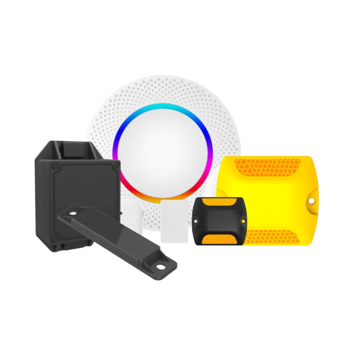
The right technology also allows detecting if a miner is down possible. I will describe how to do so using BLE beacons. 


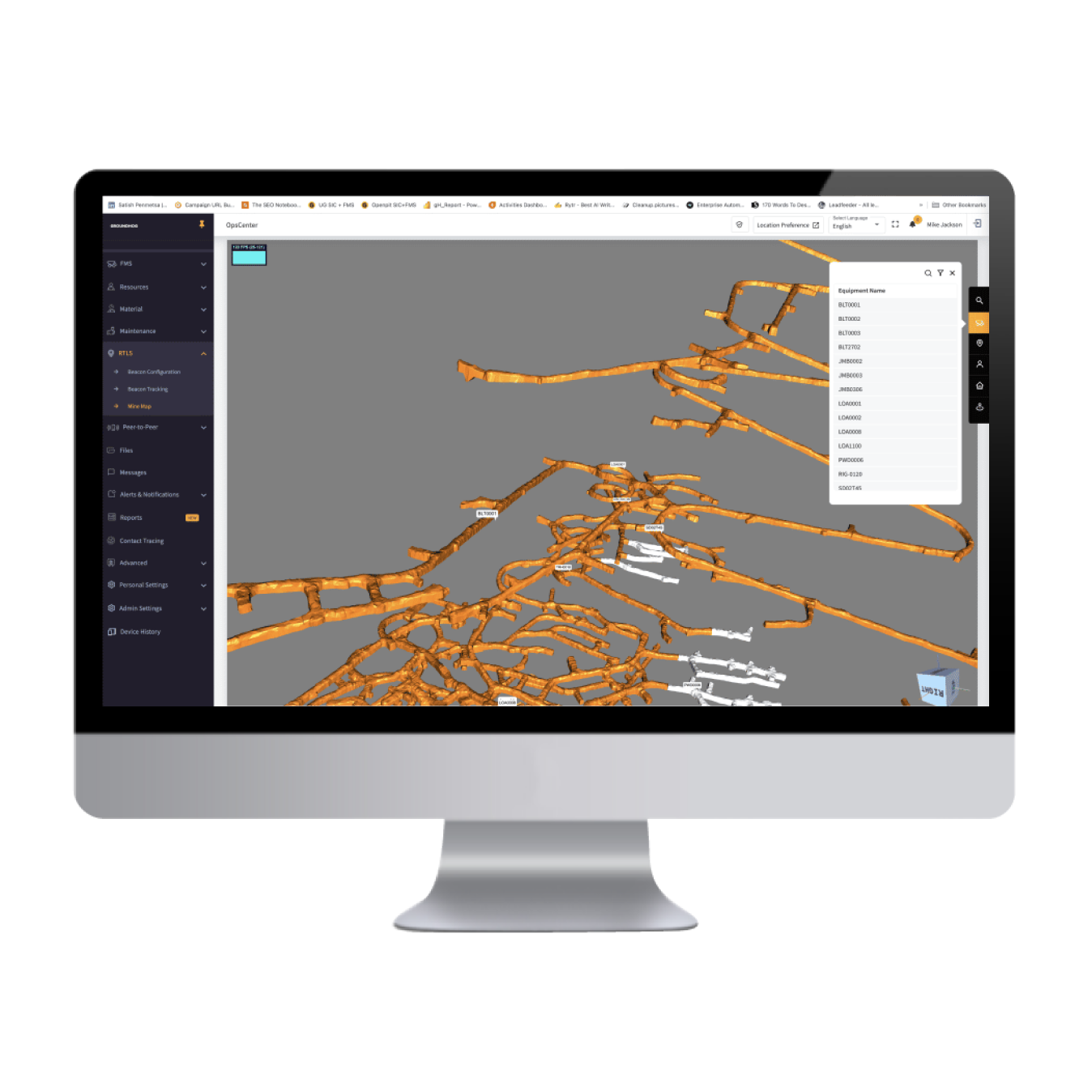
Use case #2: Locating equipment underground


Most mine operations monitor Equipment Availability and Utilization using a Time Utilization Model (TUM). When a mine seriously looks into increasing efficiency, they can pull two levers almost immediately: identify operating delays and standbys. Underground equipment sits on standby during shift change, so continuous improvement managers must look for ways to get butts-in-seats faster, thereby reducing standby times.


At shift change, locating equipment underground can often take over 20 minutes or more – especially if it is not the primary load-haul equipment. Using RTLS, a miner can visually identify the exact location of a piece of equipment at a shift change line-up meeting, thereby increasing overall effective shift time to more than 30 minutes per day.


Using simple back-of-the-envelope math: if a mine produces 2000 tons per day, assuming 21 hours of effective shift length, everything else being equal, you could achieve an additional 50 tons per day (approximately 2050 tons – or two additional truck loads). Of course, for many, load-haul equipment utilization is effective with concepts like hot-shift changes, etc. But unlocking an additional 30 minutes per shift across your workforce can improve overall productivity – think development, production, construction, electrical and mechanical ops.


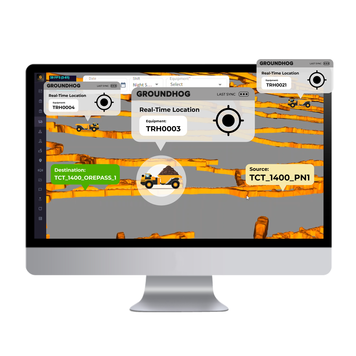
Use case #3: Automated trip counting, material inventory and movement underground.


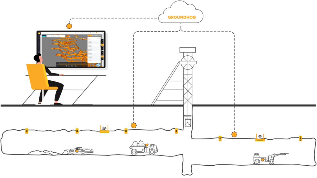
Automated counting of trips to surface is the most straightforward use case to implement using RTLS hardware. For example, in a portal access mine, installing tracking beacons and readers on the equipment and at the portal entrance, you can count the number of times a haul truck went underground and returned to surface. The limitation is that you can’t tell whether the truck is loaded. Adding a payload sensor to track actual trips with tonnes solves this problem.


Many of our customers also install sensors on loading units and the ribs of ramps, headings, muck bays, and ore pass. So when a haul truck visits a particular loader (LHD / Bogger / Scoop depending on where you are reading this article), you can assume that it got loaded, along with the location, and the grade of material, so geologists can also track the material inventory and material movement underground. 

A Real-Time Location Tracking solution uses three main components in underground mines:

  1. Beacons, sometimes called “tags,” affixed to equipment, fixed to locations, or carried by personnel
  2. Readers that read the signals from the beacons/tags
  3. A visualization tool that overlays equipment and personnel on a 3D mine map

RTLS Beacons / Tags


There are three main types of beacons (also generally called tags for gen one and gen two tech) – Time of Flight (ToF), WiFi, and Bluetooth BLE beacons. I will discuss the pros and cons of these technologies in a separate post. However, know that ToF beacons used by some solution providers use generation one technology. WiFi beacons used by some providers use generation two technology. GroundHog’s RTLS Bluetooth beacons use generation three technology. You should know that companies using Gen 1 and Gen 2 technologies can continually rebuild their systems to use Generation 3 BLE Devices.

These tags are typically installed on equipment or encapsulated in the miner’s cap lamps. Each tag has a unique ID associated with a miner or equipment.

RTLS Readers


As discussed earlier, readers installed throughout the mine detect the tag when it passes by the reader.

  • In the case of the generation one beacon, proprietary ToF readers are required and installed as a separate network over the top of your underground Ethernet network.
  • Generation two beacons use a WiFi access point to read the WiFi tag, register the ID, and the time it was detected.
  • Generation three beacons (long-range Bluetooth-based BLE) companies such as GroundHog use Bluetooth readers or tablets (iPad or Android) to detect the beacon/tag.

While the underlying technology is slightly different, they all achieve the same purpose. 

Central Monitoring System, Visualization Tools and 3D Mine Maps


A central monitoring system displays the location information on a map, allowing for real-time monitoring of the movements of personnel and equipment throughout the mine.

The final piece of the RTLS puzzle is the visualization tool. Modern visualization systems such as GroundHog import 3D mine maps from commonly used survey software in DXF or DWG files. The mine IT team configures the locations of the readers on the 3D mine map within the GroundHog RTLS system as easy as pointing to a location on the 3D mine map and assigning the beacon ID and the location’s name. 

For example, when haul-truck TRK007’s beacon passes by the muck bay MKB_1600_CT2, the GroundHog RTLS solution visualizes that TRK0097 is at MKB_1600_CT2. As a result, Mine Control/Dispatch, Superintendents, Shift Bosses, and miners can now keep track of all the equipment and personnel underground.

As we’ve outlined here, there are several benefits to using real-time location tracking in underground mining operations. The key benefits include increased safety, improved efficiency, and reduced costs.


  1. Increased safety is one of the primary benefits of real-time location tracking. Real-time monitoring of personnel and equipment makes it possible to respond quickly to incidents. RTLS also helps to minimize the risk of accidents and improve the overall safety of the mine.


  1. Improved efficiency is achieved by optimizing the flow of work and reducing downtime; real-time location tracking helps increase productivity and improve the efficiency of mining operations.


  1. RTLS also helps to reduce costs. Improved efficiency reduces waste, but more importantly, increased situational awareness and safety reduce costs.


Over the next 5-10 years, most underground mines will deploy some form of RTLS – primarily for safety use cases, with efficiency and traffic management as add-on benefits.

GroundHog
Pilot On-boarding
Process