Underground mines are like black boxes. Unlike surface mines, where you can have a dispatch tower to visually monitor where all equipment, and potentially all personnel are, in an underground mine, all you typically have is the brass board to know who went underground. And you also rely on the previous shift personnel to accurately describe where they left their tools and equipment so the current shift can get their butts-in-seats as fast as possible without spending time searching for their gear.
Add to this the fact that underground mines change every single shift. New faces get mined, old ones get backfilled, etc. RTLS (Real Time Location Services) is now being widely deployed to actively monitor all personnel and equipment underground.
RTLS is the generic term given to this enabling technology – it is like a GPS for underground mines (and tunneling projects). Multiple companies – Newtrax (part of Sandvik), Meglab and Mobilaris (both now part of Epiroc), and GroundHog have technologies that are used to implement RTLS in underground mines. This technology has proved to have a significant impact on the safety and productivity of underground mining operations.
The Importance of Real-Time Location Tracking in Mining
In software companies such as ours (GroundHog), we develop our products around use cases we can solve. So, here are a few use cases where mines – especially underground mines deploy RTLS.
Use case #1: Miner Safety
The most important use case is Safety. When you have an incident that requires all personnel to evacuate, mines can rely on RTLS to ensure that all personnel have evacuated to a mine rescue chamber, or have come to surface safely.
A central Dispatch room can also monitor lone workers, and keep track of the last known location of a miner. This helps during mine rescue operations so the rescue team can narrow down the search and rescue area.
RTLS allows for quick and accurate responses to any incidents that may occur.
With the right technology, you can also monitor if a miner is down. I will describe how this is accomplished using BLE beacons.
Use cases #2: Locating Equipment underground
Mines track Equipment Availability and Utilization down to the T – most mines use a Time Utilization Model (TUM). Here is what a sample TUM looks like. When a mine is seriously looking into increasing efficiency, two levers they can pull almost immediately is Operating Delays and Standbys. Underground equipment is in standby during shift change. So, it is imperative that a continuous improvement manager look for ways to get butts-in-seats faster, thereby reducing standby times.
At shift change, it takes about 13-17 minutes to locate equipment underground – especially if it is not the primary load-haul equipment. Using RTLS, a miner can visually identify the exact location of a piece of equipment at the shift change line-up meeting, thereby increasing overall effective shift time to about 30 minutes per day.
Doing some simple back-of-the-envelope math: if you mine about 2000 tons per day assuming 21 hours of effective shift length, everything else being equal, you could get an additional 50 tons per day (about 2050 tons – which is two truck loads). Again, chances are that your load-haul equipment is already utilized pretty effectively using concepts like hot-shift-changes, etc. But know that you are getting 30 extra minutes per shift across your entire workforce – think Development, Production, Construction, Electrical and Mechanical ops.
How Real-Time Location Tracking Works – the underlying technology
You need 3 pieces of Technology. For implementing Real Time Location Tracking in Underground Mines:
- Beacons
- Sensors that read the signals from the beacons
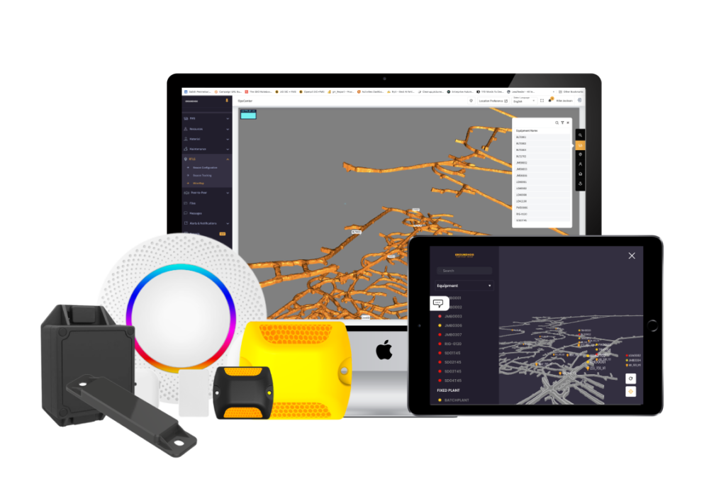
- Visualization Tools that overlay equipment and personnel on a 3D mine map
RTLS Beacons / Tags.
There are 3 main types of beacons (also generally referred to as Tags for Gen 1 and Gen 2 tech) – Time of Flight (ToF) beacons, WiFi beacons, and Bluetooth BLE beacons. I will discuss the pros and cons of each of these technologies in a separate post – just know that ToF Beacons used by companies such as Newtrax and Meglab are Generation 1. WiFi beacons used by companies such as AeroScout and Mobilaris are Generation 2. And Bluetooth beacons used by companies such as GroundHog are Generation 3. Now, you should know that companies using Gen 1 and Gen 2 technologies can always re-build their systems to use the Generation 3 BLE Devices.
These Tags are typically installed on equipment or installed within Miner’s cap-lamps. Each Tag has a unique ID and is associated with a miner or equipment.
RTLS Sensors
As discussed earlier, Sensors are installed throughout the mine – they “read” the Tag when it passed by the sensor.
In the case of Gen 1 beacons used by the likes of Newtrax and Meglab, you’d need to have specialized ToF sensors, and also install a separate network of specialized sensors that need to be connected to your underground Ethernet network.
In the case of Gen 2 beacons used by the likes of AeroScout and Mobilaris, your WiFi access point detects the WiFi Tag and registers the ID and time it saw the Tag.
In the case of Gen 3 beacons (Long Range Bluetooth based BLE) used by companies such as GroundHog, you can install a Bluetooth reader, or a simple iPad or Android Tablet to detect the Beacon / Tag.
While the underlying technology is a little different, they all achieve the same purpose.
Central Monitoring System, Visualization Tools and 3D Mine Maps
The central monitoring system then displays the location information on a map, allowing for real-time monitoring of the movements of personnel and equipment.
The third piece that completes the RTLS puzzle is the visualization tool. Modern visualization systems such as GroundHog and Mobilaris import 3D mine maps generated by Survey software such as DataMine and Deswik as DXF or DWG files. Then, Mine Engineers or Supervisors configure the locations of the sensors on the 3D mine map (e.g. within the GroundHog RTLS system).
BTW, it ain’t rocket science – in systems such as GroundHog, it is as easy as pointing to a location on the 3D mine map, and assigning the Beacon ID, and the name of the location. So, every time the Haul-truck TRK007’s beacon passes by the Muckbay MKB_1600_CT2, systems like GroundHog are able to visualize that TRK0097 is at MKB_1600_CT2. This helps Mine Control / Dispatch, Superintendents, Shift Bosses, and Miners keep track of all the equipment and personnel underground.
Benefits of Real-Time Location Tracking for Underground Mining
As I’ve outlined here, there are several benefits to using real-time location tracking in underground mining operations. These benefits include increased safety, improved efficiency, and reduced costs.
Increased safety is one of the primary benefits of real-time location tracking. With real-time monitoring of personnel and equipment, it is possible to quickly respond to any incidents that may occur. RTLS also helps to minimize the risk of accidents and improve the overall safety of the mine.
Improved efficiency is another benefit of real-time location tracking. By optimizing the flow of work and reducing downtime, real-time location tracking can help to increase productivity and improve the efficiency of mining operations.
RTLS also helps to reduce costs. Improved efficiency reduces costs. But even more importantly, increased situational awareness and safety reduce costs.
Finally…
Over the next 5-10 years, most underground mines will have some form of RTLS deployed – primarily for safety use cases, with efficiency and traffic management as add-on benefits.